
About this app
Introduction
Designbotic Terrain is a powerful tool designed for Autodesk® Revit® users, specifically from versions 2020 to 2024. This plugin simplifies the process of creating geolocated toposurfaces from ESRI grid files, providing a seamless workflow for architects, engineers, and designers. With its unique features and capabilities, Designbotic Terrain stands out as an essential addition to any Revit user's toolkit.

(Image by: Designbotic)
Key Features
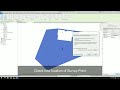
One of the standout features of Designbotic Terrain is its ability to import ESRI grid files (.asc) into Revit and create precise geolocated toposurfaces. These grid files are commonly obtained from GIS services and typically cover large areas with hundreds of thousands of data points. Importing such massive datasets directly into Revit can be cumbersome and resource-intensive. Designbotic Terrain addresses this challenge by allowing users to load only the necessary portion of the ESRI file, making the process more manageable and efficient.
Additionally, the plugin requires a geolocated .dxf file with a plot, which helps adjust the survey point of the project. This ensures that the terrain surface is accurately positioned and trimmed before being loaded into Revit. By streamlining the geolocation and cropping processes, Designbotic Terrain significantly optimizes resource utilization and enhances overall performance.

(Image by: Designbotic)
Performance and Efficiency
Designbotic Terrain excels in handling large areas with a high density of data points, which are common characteristics of ESRI grid files. Importing such extensive datasets directly into Revit can lead to freezing and slowdowns, hindering productivity and workflow. However, with Designbotic Terrain, users can seamlessly import ESRI grid files without compromising performance. The plugin effectively manages the processing of large amounts of data, ensuring a smooth and efficient experience for Revit users.
Moreover, Designbotic Terrain provides users with the flexibility to work with geolocated terrain files as well as non-geolocated ones. This versatility allows for a wide range of applications and scenarios, catering to diverse project requirements and preferences. Whether dealing with specific geolocation needs or general terrain modeling tasks, Designbotic Terrain offers a comprehensive solution that meets the demands of various projects.

(Image by: Designbotic)
Conclusion
In conclusion, Designbotic Terrain is a valuable asset for Autodesk® Revit® users seeking an efficient and reliable tool for creating geolocated toposurfaces. With its advanced features, seamless workflow, and optimized performance, this plugin simplifies the process of importing ESRI grid files and generating precise terrain models in Revit. By streamlining geolocation, trimming, and cropping processes, Designbotic Terrain enhances productivity and workflow efficiency, making it an indispensable tool for architects, engineers, and designers. Whether working on large-scale projects or smaller-scale designs, Designbotic Terrain delivers exceptional results and empowers users to achieve their creative vision with ease.

(Image by: Designbotic)

(Image by: Designbotic)